|
Reported Crop Circles for the State
of Washington -
Walla Walla / Cottonwood Canyon, Walla Walla County (July 4, 1999)
The circle formation appeared right on the border of Washington state and Oregon (one of the harvesting lines in the picture is where the border actually is). The lay was reported as being counterclockwise near the outside of the circles, but as you approached the center it reversed direction to being clockwise in 4-5 bands. The wheat was of the delicate bearded variety, and was bent in two places: about 2 off the ground, and again at the last node before the seed head (likely due to phototropism, indicating that formation was much earlier than discovery). The soil in the formation was baked like concrete. Possible EM effects on people/animals reported. *Possible second formation in the area (rumored).
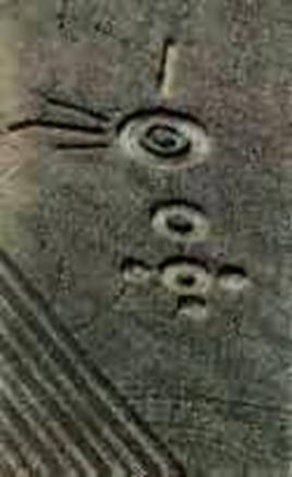
Crop
type: wheat
Source: Jeffrey Wilson
|
|
City
/ County / Date:
- Sacajawea
/ Pasco, Cowlitz County (1945)
- Moses
Lake, Grant County (August 21, 1964)
- Custer,
Whatcom County (January 1, 1965)
- Lynden,
Whatcom County (January 12, 1965)
- Harrah, Yakima County
(January 19, 1977)
- Centralia,
Lewis County
(April 1980)
- Kennewick,
Benton County
(May 28, 1993)
- Chehalis,
Lewis County
(July 8, 1994)
- Adna (1), Lewis County
(October 16, 1994)
- Adna
(2), Lewis County
(October 16, 1994)
- Chehalis,
Lewis County
(July 17, 1996)
- [Unknown]
(May 29, 1997)
- Coupeville
(1), Whidbey Island, Island County (May
26, 1998)
- Coupeville
(2), Whidbey Island, Island County (May
26, 1998)
- Eltopia
/ Pasco, Franklin County (June 19, 1998)
- Walla
Walla / Cottonwood Canyon, Walla Walla County (July 4, 1999)
- Burlington,
Skagit County
(September 8, 1999)
- Snohomish County (Fall, 2003)
- St.
John, Whitman County
(July, 2004)
- Wilbur,
Lincoln County
(June 27, 2007)
- Wilbur,
Lincoln County
(July 23, 2009)
|


